Documents/FAQs
Project documents
This page contains all relevant documents and information being consulted upon.
The Statutory Consultation ran from 26 October 2023 and until 7 December 2023.
Sometimes these documents are quite large files, so if you have any problems with downloading them, let us know and we’ll see how we can help.
Statutory Consultation Documents - 26 October to 7 December 2023
Consultation Documents - Overview
PEIR Volume 1 - Non Technical Summary (NTS)
PEIR Volume 2 - Main Text
Chapter 3 – Site and Development Description
Chapter 4 – Alternatives and Design Evolution
Chapter 5 – Construction & Decommissioning Methodology & Programme
Chapter 7 – Landscape and Views
Chapter 10 – Transport and Access
Chapter 11 – Noise and Vibration
Chapter 14 – Soils and Agricultural Land
PEIR Volume 3 - Appendix
Appendix 1.1 – Statement of Expertise
Appendix 2.2 – Scoping Opinion
Appendix 2.3 – Qualitative Dust Assessment
Appendix 2.4 – Phase 1 Ground Conditions Assessment (Part 1)
Appendix 2.4 – Phase 1 Ground Conditions Assessment (Part 2)
Appendix 2.5 – Solar Photovoltaic Glint and Glare Study
Appendix 3.1 – BESS Safety Management Plan
Appendix 4.1 – Opportunities and Constraints for Site Selection
Appendix 6.1 – Cultural Heritage Technical Appendix
Appendix 6.2 – Archaeological Mitigation Strategy
Appendix 6.3 – ASWYAS Geophysical Survey
Appendix 6.4 – Email Correspondence with NYC Conservation Officer
Appendix 6.5 – Correspondence with the NYC Archaeologist 1 of 3
Appendix 6.6 – Correspondence with the NYC Archaeologist 2 of 3
Appendix 6.7 – Correspondence with the NYC Archaeologist 3 of 3
Appendix 7.1 – LVIA Methodology
Appendix 7.2 – Viewpoint Correspondence
Appendix 7.3 – Landscape Effect Table
Appendix 7.4 – Site Appraisal Photographs
Appendix 7.5 – Representative Viewpoints
Appendix 7.6 – Visual Effects Table
Appendix 7.7 -Visualisations (see Visualisations section below)
Appendix 8.1 – Habitats and Desk Study Baseline Report
Appendix 8.2 – Ornithological Survey Report
Appendix 8.3 – Otter and Water Vole Report
Appendix 8.4 – Confidential Badger Report (Abridged Version)
Appendix 8.5 – Amphibian Baseline Report
Appendix 8.6 – Aboricultural Impact Assessment
Appendix 9.1 – Flood Risk Assessment and Appendices
- App 1 – DX-01-P01 Rev 07 Site Location Plan
- App 2 – Parameter Plan
- App 3.1 – Fig A8-F Pages from Strategic Flood Risk Assessment Level 1-2
- App 3.2 – Fig A8-F Pages from Strategic Flood Risk Assessment Level 1
- App 4 – E216 – 107A-127A Existing Drainage Arrangements (LR)
- App 5 – Drax_UAV_TOPO_Linework_OSGB36_ODN_Rev1_2022-05-06-PlotA0 -LR
- App 6 – E216-82 Rainfall Maps (LR)
- App 7.1 – Email to EA
- App 7.2 – Your Enquiry_RFI_2022_272419
- App 7.3 – Asset Map 272419 – Mark Up
- App 7.4 – Defence Details 272419
- App 7.5 – Historic Flood Map 272419 – Mark Up
- App 7.6 – Supporting information 272419
- App 8 – E216-84B – Flood Defences – Design SOP (LR)
- App 9.1 – 230823_AEG0851_YO8_EnsoEnergy_005
- App 9.2 – 2022s0454 – Selby Solar Farm – Method Review
- App 10 – E216-09B 1in200yr+CC Tidal Def Depth (LR)
- App 11 – E216-26B 1in100yr+CC Fluvial Def Depth (LR)
- App 12 – E216-21B 1in200yr JP Def Depth (LR)
- App 13 – E216-02B RoFSW Depths 1 in 1000yr (LR)
- App 14 – E216-134 BESS Flood Compensation Earthworks
- App 15 – E216-06C Watercourse Buffers
- App 16 – 230802_WaterCourse Buffers (LR)
- App 17.1 – E216 Pre-development runoff rate V2
- App 17.2 – E216 Post-development runoff rate V2
- App 18 – E216-90B-106B Preliminary Surface Water Drainage (LR)
- App 19 E216-88 Preliminary Drainage Strategy – BESS
- App 20.1 E216 – BESS and Substation Network Results for Pond 1 V3
- App 20.2 E216 – BESS and Substation Network Results for Pond 2 V3
- App 21 – E216 – FN -Drainage Checklist
Appendix 9.2 – LLFA Consultation
Appendix 9.3 – IDB Consultation
Appendix 9.4 – EA Consultation
Appendix 11.1 – Time History and Statistical Analysis Graph
Appendix 11.2 – Correspondence with Selby District Council Environmental Health Officer
Appendix 11.3 – Traffic Flow Data
Appendix 12.1 – Helios Traffic Flows
Appendix 12.3 – Helios Carbon Calculations
Appendix 12.4 – Mean Air Temperature Anomaly
Appendix 12.5 – Average Annual Precipitation Anomaly
Appendix 12.6 – Maximum Summer Temperature Anomaly
Appendix 12.7 – Summer Precipitation Anomaly
Appendix 12.8 – Minimum Winter Temperature Anomaly
Appendix 12.9 – Winter Precipitation Anomaly
Appendix 12.10 – Annual Cloud Anomaly
Appendix 14.3 – Outline Soil Management Plan
Appendix 14.4 – Note About UK Agriculture
(PEIR Appendix 7.7) - Visualisations
Appendix 7.7 Visualisations 1 of 19 Viewpoint 1
Appendix 7.7 Visualisations 2 of 19 Viewpoint 2
Appendix 7.7 Visualisations 3 of 19 Viewpoint 3
Appendix 7.7 Visualisations 4 of 19 Viewpoint 4
Appendix 7.7 Visualisations 5 of 19 Viewpoint 5
Appendix 7.7 Visualisations 6 of 19 Viewpoint 6
Appendix 7.7 Visualisations 7 of 19 Viewpoint 7
Appendix 7.7 Visualisations 8 of 19 Viewpoint 10
Appendix 7.7 Visualisations 9 of 19 Viewpoint 14
Appendix 7.7 Visualisations 10 of 19 Viewpoint 15
Appendix 7.7 Visualisations 11 of 19 Viewpoint 16
Appendix 7.7 Visualisations 12 of 19 Viewpoint 20
Appendix 7.7 Visualisations 13 of 19 Viewpoint 21
Appendix 7.7 Visualisations 14 of 19 Viewpoint 22
Appendix 7.7 Visualisations 15 of 19 Viewpoint 23
Appendix 7.7 Visualisations 16 of 19 Viewpoint 24
Appendix 7.7 Visualisations 17 of 19 Viewpoint 26
Informal Consultation: Phase 1 - July 2022
The consultation materials for the Phase 1 informal consultation (Summer 2022) are listed below (please note, these documents are now superseded with the statutory consultation materials listed above):
Frequently Asked Questions
What are we proposing to develop?
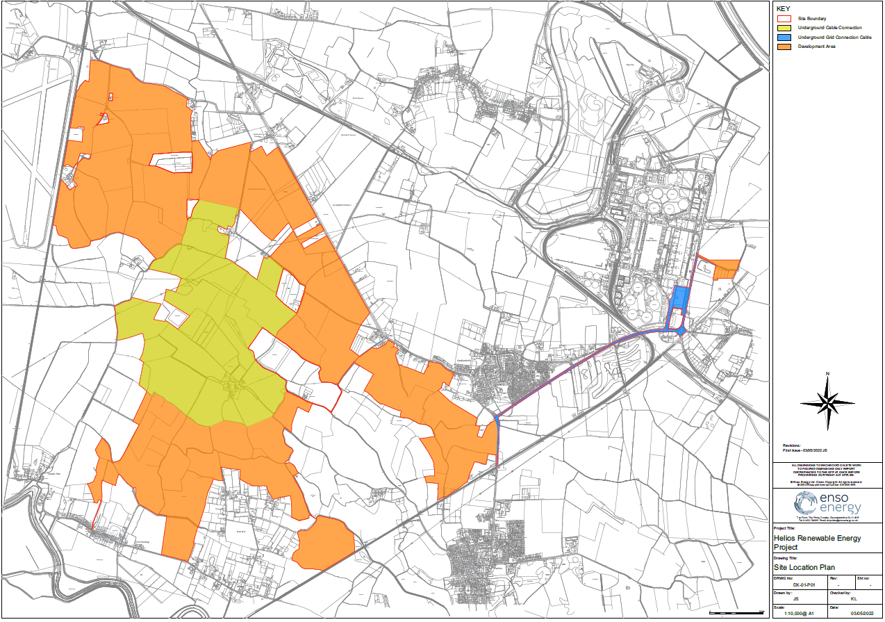
We are proposing to develop a solar farm with a battery energy storage system and associated infrastructure on land west of Camblesforth and north of Hirst Courtney in North Yorkshire.
The proposed solar farm would provide renewable electricity for distribution to the National Grid via a connection to the Drax National Grid 132Kv Substation, adjacent to Drax Power Station.
The proposal would generate a significant amount of energy each year of the proposed 40-year operational life, while also providing large CO2 savings when compared to generation of electricity by non-renewable sources, moving us closer to net zero.
In response to the feedback we received during our earlier consultation in 2022, we have developed a new Site Layout, which has reduced the overall footprint of the site (from 757 hectares to 476 hectares) and identified specific areas for landscaping and biodiversity net gain areas, helping screen the solar panels, encourage pollinators and improved local wildlife habitats.
Who is the applicant?
The applicant is Enso Green Holdings D Limited. Enso Green Holdings D Limited is a joint-venture partnership between Enso Energy and Cero Generation.
Enso Energy is one of the UK’s most experienced renewable energy developers, with an unparalleled focus on solar energy.
Cero Generation is a leading solar energy company, working across Europe to support the transition to a net-zero future.
You can find out more about Enso Energy and Cero Energy by visiting: https://ensoenergy.co.uk/
Where is the site?
The site is located south-west of Camblesforth, which lies southeast of Selby, and to the west of Drax Power Station. The southern parts of the site lie to the north of the village of Hirst Courtney. The cable route corridor extends to the east of Drax Power Station.
A site plan can be found here.
Why here?
One of the key drivers for siting renewable energy projects is being close to a suitable connection point to export power to the National Grid. A point of connection to the National Grid at Drax Power Station has been agreed, and the land identified for the project has been refined following a site selection process.
What are the impacts on the local environment and biodiversity?
A well-designed solar farm provides many opportunities for local ecological and biodiversity improvement particularly on land that has previously been intensively farmed. Potential biodiversity enhancements include reinforcement of existing and planting new hedgerows, planting of native grasses and wildflowers within and around the solar farm itself.
Further detailed information about the proposed biodiversity enhancements can be found on the Landscape Strategy Plan and consultation materials.
Will the impacts to agricultural land be taken into consideration?
Yes. As noted above, one of the key influences on where a project like can be be built is the proximity to an available grid connection. Understanding the nature and quality of the land (Agricultural Land Classification – ALC) within the site is an important assessment that we have undertaken as we have progressed the scheme design.
For context, the latest agricultural land statistics* (DEFRA, 2021) state that in 2021, there was just over 8.8 million hectares of utilised agricultural land in England. A recent publication by the Conservative Energy Network (CEN) states that ‘Currently, 0.08% of all land is taken up by solar farms.
This would only increase to just under 0.4% if we managed to increase solar coverage to 70GW of capacity, which the Energy Security Strategy stated as the target for 2035.
This is the equivalent of less than one third of the land currently occupied by golf courses across the United Kingdom’.**
The solar panels will be fixed to the ground on fully removeable piled frames which will be removed in the decommissioning phase. There are areas within the site where fixed equipment is proposed which will, for the purpose of assessment, be considered as permanent development. These make up less than 3% of the site. The ALC grading and quantum of these areas has been considered and the significance of the loss assessed against the methodology in IEMA’s “A New Perspective on Land and Soil in Environmental Impact Assessment” (2022). A Soil Resource Plan, as necessary tied in with a Soil Management Plan, can be used to avoid or reduce the impacts on agricultural land.
*Available at: https://www.gov.uk/government/statistics/farming-statistics-land-use-livestock-populations-and-agricultural-workforce-as-at-1-june-2021-england Accessed in May 2022.
**https://www.cen.uk.com/our-blog-list/2022/6/1/how-harnessing-the-sun-can-help-secure-our-energy-and-food-supplies Accessed June 2022
Will the project mean that the existing footpaths and rights of way will be closed?
No. Existing rights of way will remain accessible during construction and operation. The scheme will be designed around existing public rights of way (PROW) so as to avoid any long term diversions or changes to these routes.
In addition, we have proposed to include a new permissive footpath within the proposals to improve pedestrian connections between Camblesforth and Carlton.
Will the proposals cause an increase in flood risk locally?
Solar panels are mounted on frames which are driven into the ground, meaning that dispersal of rainwater can continue. Where more permanent bases are required (such as for the transformers and energy storage facility) extensive assessment will be undertaken, with mitigation provided to ensure that there is no net increase in flood risk.
The Environmental Impact Assessment (EIA) work will need to demonstrate that we have undertaken extensive assessment of drainage and flood risk, and put in place any mitigation measures to ensure that there is no net increase in water runoff from the site.
Further information about our assessment of flood risk can be found in Chapter 9 of the PEIR documents here.
Will the solar panels be visible from my house?
Visibility of the site from surrounding areas has been a key design consideration.
To assess what the proposed scheme would look like, a Landscape and Visual Impact Assessment (LVIA) is being carried out as part of the EIA. This gives information on the design of the scheme and will identify key areas where visual and landscape mitigation (such as planting) is required.
The solar panels will be fixed to the ground on piled frames which will be fully removed in the decommissioning phase.
The panels will sit no higher than 3 metres from the ground, which, given the flat nature of the surrounding land, means that many will be screened from view from existing hedgerows, through enhancing existing hedgerows or planting new ones.
An assessment of various viewpoints around the site has been undertaken, with visualisations to help show what the site would look like from locations around the site. These can be viewed in Appendix 7.7 of the PEIR on the Documents/FAQ page.
Will panels cover the whole area?
No. There will be lots of green space all over the site. There will be gaps between each row of solar panels which will remain grass, and grass will grow underneath each row of panels.
Existing hedgerows and trees will be maintained, with buffers to allow for landscaping and there will also generally be at least five metres of open field space between security fencing and solar panels throughout the whole site. There will also be new areas of wild meadow planting, new trees and hedgerows will be planted, and there will be farm-style tracks to facilitate maintenance between the parcels of land.
Further details of the approach to planting and screening is contained in Chapter 7 of the PEIR.
When the panels reach the end of their life, will the land be deemed ‘brownfield’ making it easier to build on in future?
No. The planning approval will require the site to be fully decommissioned and returned to agricultural use at the end of the project life. This application will not change the classification of the land.
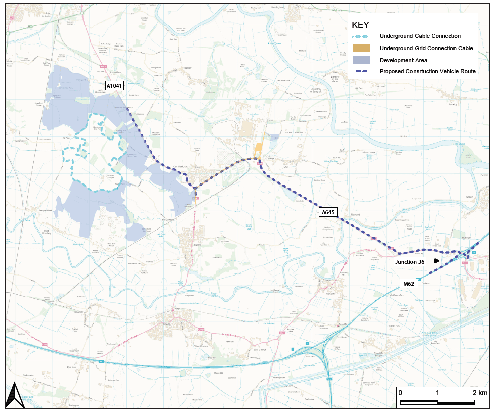
Will these proposals cause additional traffic through Camblesforth, Hirst Courtney, Carlton and surrounding villages?
The Project have been consulting closely with the traffic management teams at North Yorkshire Council on local construction routes.
The anticipated average number of HGV deliveries would be 36 per day (18 arrivals and 18 departures) across the 12 month construction period. At its peak, 52 HGV movements are expected (26 arrivals and 26 departures).
The suitability of these routes will be confirmed by detailed on-site assessment and traffic surveys and agreed with North Yorkshire Council and National Highways.
Our traffic assessments show that there is likely to be very little impact on the local road network. However, a Construction Traffic Management Plan (CTMP) will be prepared to outline specific points, such as delivery times, restrictions, and routes to ensure that construction traffic does not have a detrimental impact to the local road network. An Outline CTMP will be available to review within the Environmental Statement, as part of the main DCO application.
Who will decide whether or not this Project receives planning permission?
Due to the nature of the proposed Project, an application to the Planning Inspectorate will be submitted under the Nationally Significant Infrastructure Project (NSIP) regime (Planning Act 2008) in 2023.
NSIPs are major infrastructure projects such as new harbours, roads, power generating stations (such as larger scale solar farms) and electricity transmission lines, which require a type of consent known as ‘development consent’ under procedures governed by the Planning Act 2008.
Development consent, where granted, is made in the form of a Development Consent Order (DCO).
Anybody wishing to construct an NSIP must first apply for consent to do so. For such a project, the Planning Inspectorate examines the application and will make a recommendation to the Secretary of State for Business, Energy and Industrial Strategy, who will make the decision.
Further information about the process can be found here.
How will the proposed project benefit the local community?
This scheme represents an important contribution to meeting the UK’s legally binding target under the Climate Change Act 2008 to achieve a ‘net zero’ carbon by 2050.
Renewable energy developments deliver secure supply of low carbon electricity for local communities and the wider population that is generated domestically using the UK’s natural resources. Solar power represents a ‘clean’ source of energy as it does not release any harmful emissions or pollutants.
Solar energy is also one of the cheapest forms of power generation in the UK and, in the future, can deliver lower energy bills for consumers by reducing the UK’s energy market’s reliance on foreign energy imports. This will help ensure a secure energy supply for future generations.
In addition, local benefits include:
- Local jobs and investment – we are committed to using local labour and contractors wherever we can throughout the construction and ongoing operational life of the project.
- Potential biodiversity enhancements including reinforcement of existing hedgerows and the planting of new hedgerows, native grasses and wildflowers within and adjacent to the solar farm itself.
- Maintenance and enhancement of footpaths throughout the site as well as identified additional permissive footpaths to improve connectivity in the local area.
- Community Benefit Contribution – A contribution to a community benefit fund is being considered to assist with local schemes, initiatives, and worthy causes. Through the consultation process, we are also keen to hear about any other potential local benefits that we could facilitate or deliver directly.
When will an application be submitted?
We are currently aiming to submit an application to the Planning Inspectorate in 2024.
When will the statutory consultation take place?
Informal consultation took place in July 2022 in the lead up to the statutory consultation process taking place between 26 October and 7 December 2023.
The website contains details about how to provide your comments (via an online form, freepost or freephone) and will be regularly updated over coming weeks. Further information can be found here.
How can I contact the Project Team to find out more and provide my comments?
You can get in touch with us in a number of ways. The website is the best place to start: www.helios-renewable-energy-project.co.uk. You can also email us at [email protected]. We have an online comment form to provide your comments or ask any questions.
We also have a freephone number (0800 0699 0081). If you wish to write to us, you can post to ‘FREEPOST TC CONSULTATION’ (no further stamp or address required).